Application · ADAS
Tracking a vehicle from its wheel rotation where satellite positioning fails

In brief
Satellite positioning can fail in urban, indoor or underground environments. A Wheel Pulse Transducer is an optical encoder mounted on the vehicle wheel. It counts the rotation of the wheel, which gives the distance traveled. That distance feeds a dead reckoning system, serves as the distance measuring instrument of a mobile mapping system, or acts as a reference to check an accelerometer-based system.
- 512 ppr
- optical encoder described in the source article
- 1 024 ppr
- after combining the two quadrature channels
- IP67
- with rotary seals
Why count wheel rotation
Autonomous vehicles rely on GNSS to know where they are. The signal is not available everywhere: it can fail between buildings, indoors and underground. A dead reckoning system fills these gaps by working out the position from the distance the vehicle has traveled.
The wheel is a direct place to measure that distance. An encoder on the wheel gives its angular position and angular velocity, and the distance follows from the number of wheel rotations.
Curves, direction and weather
Three things have to be handled on the vehicle. In a curve, the inner and outer wheels do not travel the same distance, so one encoder is not enough. The vehicle may also move backwards, so the encoder must sense the direction of rotation. And the sensor sits outside, on the wheel, in rain, snow and dirt.
An encoder on each side of the vehicle
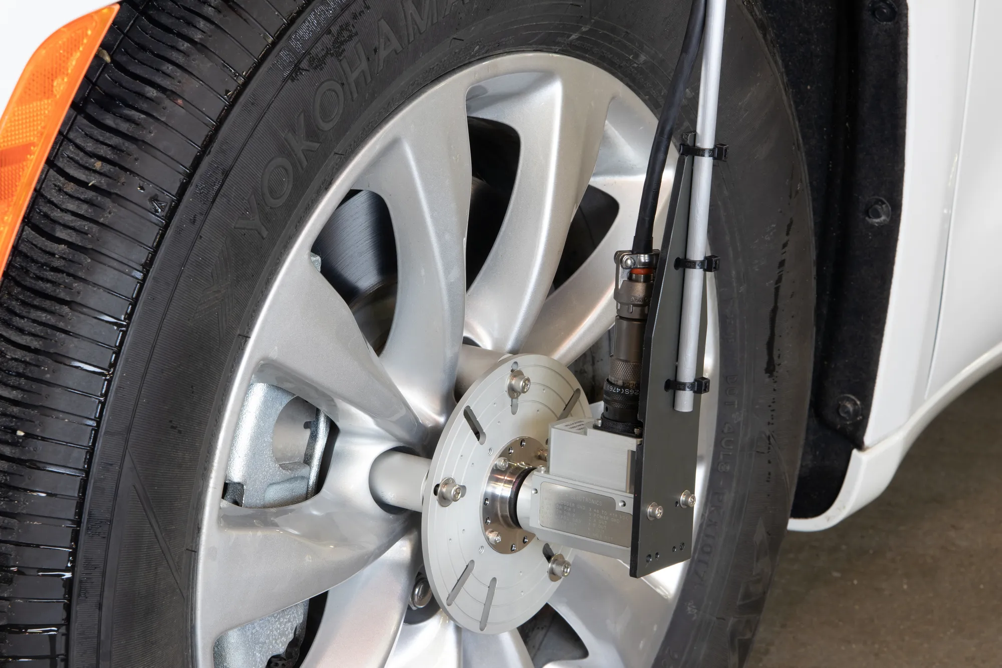
The Wheel Pulse Transducer is an optical encoder in a sealed, corrosion-resistant metal housing, mounted outboard of the wheel. Its resolution is chosen at order, from 50 to 5 000 pulses per revolution. The encoder described in the source article has 512 pulses per revolution and two channels in quadrature. The electronics combine the two channels with an exclusive OR, which doubles the resolution to 1 024 pulses per revolution.
- 01
Mount the encoder on the wheel
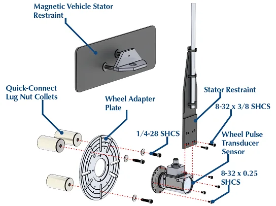
The encoder module is fixed to a wheel plate, and the plate is mounted on the wheel with collet lug extensions. Plates come in 6, 8 or 10 in, and the collets in 27 designs.
Wheel Pulse Transducer - 02
Hold the stator
A magnetic vehicle stator restraint and a restraining rod hold the stator of the encoder in place while the vehicle is driven.
- 03
Fit one encoder per side
With an encoder on both sides of the vehicle, the difference between the two wheels in curves and cornering is measured and can be compensated.
- 04
Seal it for the weather
Contacting rotary seals make the encoder weatherproof, rated IP67, for rain, snow or dirt. The maximum speed is then 3 000 rpm; without the seals, in dry conditions, it is 10 000 rpm.
The distance instrument of a mobile mapping system
Vehicle-based mobile mapping systems use a distance measuring instrument, or DMI: a wheel sensor that works out the distance from the wheel rotation. The Wheel Pulse Transducer does this job. It mounts on the wheel and connects to the position and orientation module and the imaging modules of the mapping system, where its data supplements the GPS or GNSS signal.
Users can pair the encoder with LiDAR, high-resolution cameras and GPS in multi-sensor SLAM algorithms, to collect geospatial data for mapping and for indoor and outdoor 3D models.

Warehouses, mines and sensor validation
Where GNSS tracking is not available at all, the vehicle has to be located by other means, such as wheel encoders or accelerometers. Two examples are autonomous forklifts inside warehouses and autonomous underground mining equipment.
The same wheel data can also be used as a reference, to test and validate the accuracy of accelerometer-based systems.
What you get
The distance traveled by the vehicle, measured at the wheels and independent of the satellite signal. It fills the gaps in GNSS for dead reckoning and mapping, and gives a reference to check other positioning sensors.
Frequent questions
How does a vehicle keep its position when the GNSS signal is lost?
A dead reckoning system works out the position from the distance the vehicle has traveled. An encoder mounted on the wheel counts the wheel rotation, which gives that distance without the satellite signal.
Why fit a wheel encoder on both sides of the vehicle?
In a curve, the inner and outer wheels do not travel the same distance. With an encoder on each side, the difference between the two wheels is measured and can be compensated.
What is a DMI in a mobile mapping system?
A DMI, or distance measuring instrument, is a wheel sensor that works out the distance traveled from the wheel rotation. It connects to the position and orientation module of the mapping system and supplements the GPS or GNSS signal.
Can a wheel-mounted encoder be used in rain, snow and dirt?
Yes. The Wheel Pulse Transducer accepts rotary seals, which make it weatherproof. It is IP67 with the seals fitted.